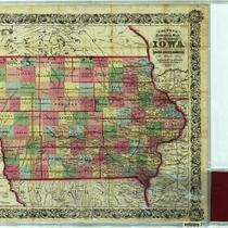
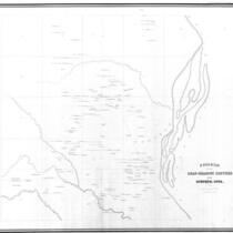
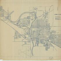
Iowa Historic Sheet Maps

1 to 48 of 176 Objects

Pages

Allen rate map of Iowa, 1902
Allen's outline map of Ottumwa, Iowa, 1891
Allen's suburban map of Council Bluffs, Iowa, 1898
Asher & Adams' Iowa, 1872
Asher & Adams' Iowa, 1873
The campus of the State University of Iowa, 1930
The Carroll Sentinel's twentieth century map of Carroll County, Iowa, 1901
Chicago Great Western Ry.,
Chicago Great Western Ry., "Maple Leaf Route," 1897
Colton's township map of the state of Iowa, 1854
Colton's township map of the state of Iowa: compiled from the United States surveys & other authentic sources, 1855
County & township map of the states of Iowa and Missouri, 1882
County & township map of the states of Iowa and Missouri, 1884
County map of the states of Iowa and Missouri, 1860
County map of the states of Iowa and Missouri, 1871
County map of the states of Iowa and Missouri, 1872
The Denison Bulletin's map of Crawford County, 1898
Diagram of the Lead-Bearing Crevices near Dubuque, Iowa, 1858
The Federal Aid Highway System progress map: Eastern Iowa and Western Iowa, 1927
The Federal Aid Highway System progress map: Eastern Iowa and Western Iowa, 1934
The Federal Aid Highway System progress map: Eastern Iowa and Western Iowa, 1935
Fort Dodge, Iowa, 1896
Geologic map of Iowa, 1916
Geologic map of Iowa, 1937
A geological map of Iowa, 1904
A geological map of Iowa, 1922
Gray's atlas map of Iowa, 1873
Henn Williams & Co.'s sectional map of the state of Iowa, 1858
Highway map of Iowa, 1949
Historical maps depicting the 13 original states from New Hampshire to Geogia at the time of the formation of the constitution, 1937
Illinois, Missouri & Iowa, 1864
Iowa : showing routes of proposed rail roads &c, 1851
Iowa, 1843
Iowa, 1843
Iowa, 1845
Iowa, 1845
Iowa, 1846
Iowa, 1846
Iowa, 1847
Iowa, 1847
Iowa, 1855
Iowa, 1855
Iowa, 1855
Iowa, 1855
Iowa, 1856
Iowa, 1856
Iowa, 1858
Iowa, 1858
Iowa, 1858
Iowa, 1858
Iowa, 1859
Iowa, 1859
Iowa, 1875
Iowa, 1875
Iowa, 1884
Iowa, 1884
Iowa and Wisconsin, 1838
Iowa and Wisconsin, 1842
Iowa City, 1947
Iowa City, 1947
Iowa City and its environs, 1854

Pages