Jump to navigation
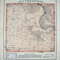
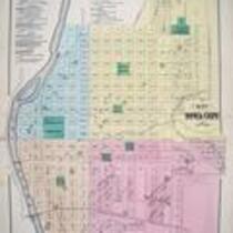
Combination atlas map of Johnson County, Iowa, 1870
1870
Thompson and Everts
Thompson and Evert's 1870 Combination atlas map of Johnson County, Iowa.
English
1870-1880
United States
Iowa
Johnson County
1 atlas: 37 pages ; 44 cm.
University of Iowa. Libraries. Map Collection
Photographed with Nikon D70 digital camera ; Lighting was produced by 6 x 27 watt compact fluorescent bulbs @ 5100K full spectrum color temperature ; Images optimized for color in Adobe Photoshop Elements ; TIFF image: 8,339,320 bytes, 1796 x 1544; JPG2000 image: 3,447,946 bytes
2005-05-13
Material in the public domain. No restrictions on use.
Contact the University of Iowa Libraries Map Collection: http://www.lib.uiowa.edu/sc/contact/
Still image Text
atlases
jp2